AKYS ground-level digital twin and urban intelligence city map
SYS_MODE: LIDAR_SCAN_3D
GPS_LOC: 54.6872° N, 25.2797° E
FPS_RATE: 60 Hz
GRID_RES: 0.02 M
11K Urban Intelligence. Mobile LiDAR Mapping.

Seeing
what others
can't.

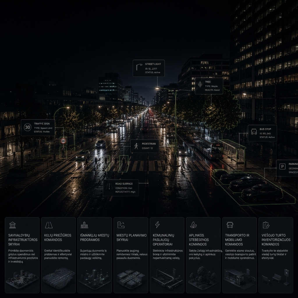
High-fidelity terrestrial digital twins powered by 11K Insta360 Titan imaging, high-density mobile LiDAR, and custom AI infrastructure models.

11K 360° Vision

Crystal-clear Insta360 Titan reality capture.

Mobile LiDAR

Centimeter-level accuracy at traffic speed.

AI Models

Automated infrastructure and road analytics.

Digital Twins

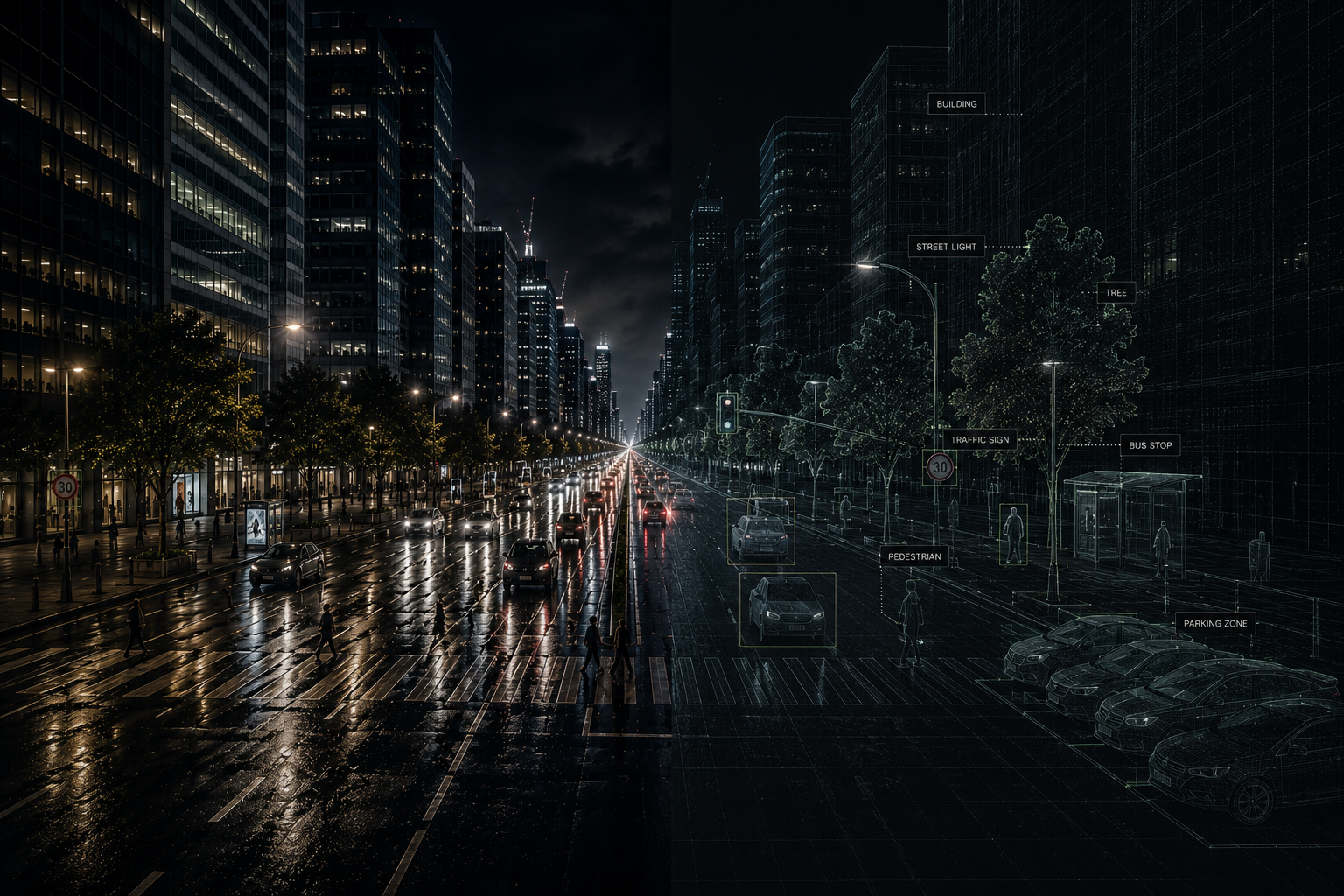
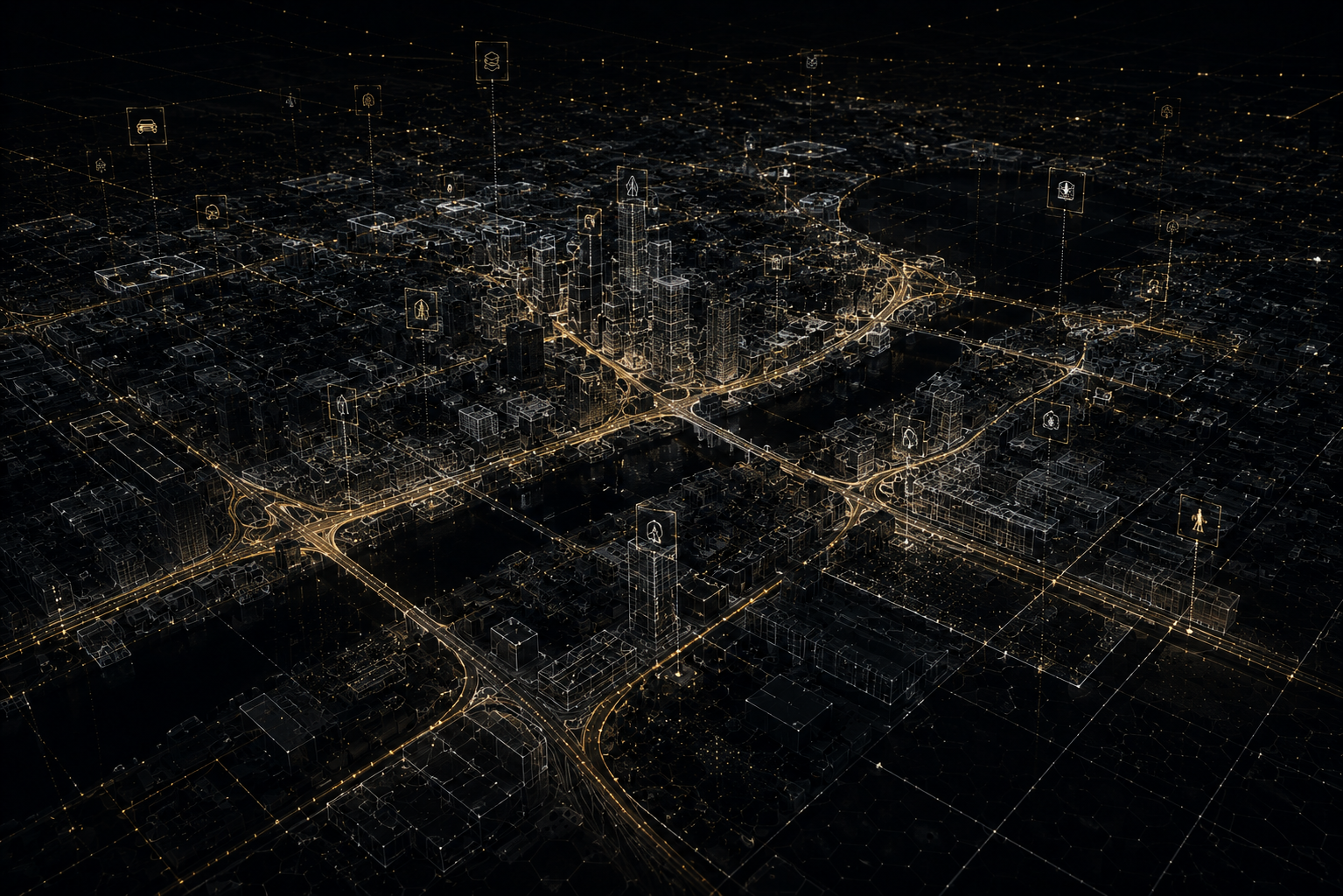
Living semantic maps for modern cities.

Scroll
Advanced Sensors

11K Mobile Mapping System.

AKYS Mobile Mapping System Technology Rig
01
02
03
04
05
06
07
08
09

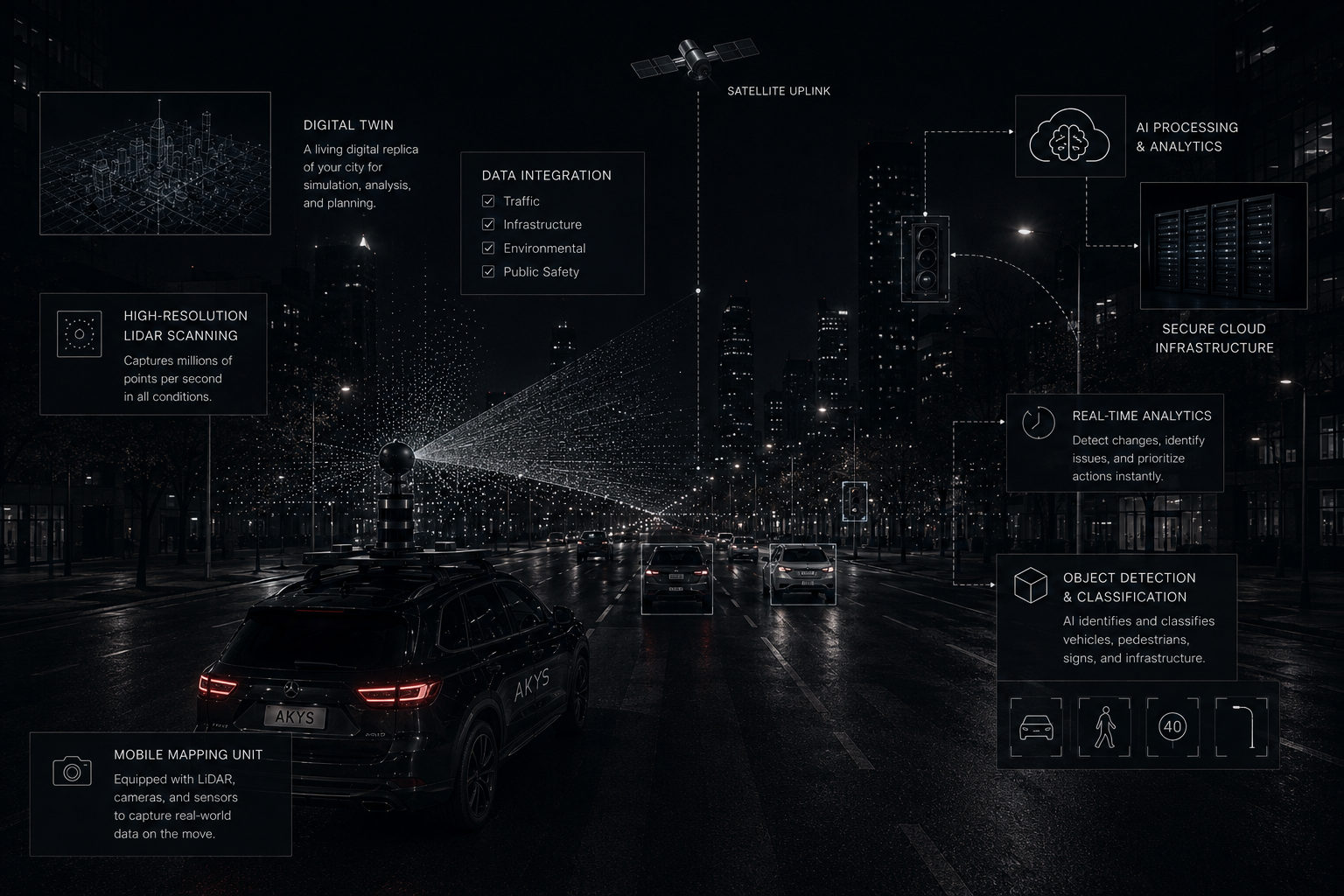
Our custom 'Capture Cannon' rig integrates the Insta360 Titan with dual high-density mobile LiDAR, thermal LWIR, and RTK-GNSS to digitize urban infrastructure with ±3cm precision.

  • Dual High-Density LiDARFull 360° point cloud generation for road and overhead assets.
  • Insta360 Titan 11K Array Flagship Advantage
    cinematic street-level imagery with sharp detail for AI training and digital twins
  • ZED 2i & 4K Stereo Visionreal-time 3D depth and object measurement
  • Thermal LWIR Imagingdetects heat loss and urban heat islands
  • AI Road Inspection Camerasidentifies cracks, asphalt damage, and road marking wear
  • Environmental Sensor Suitemonitors CO2, PM10, temperature, humidity, and air pollution
  • Spatial Audio Mappinganalyzes urban noise and traffic acoustics
  • RTK + IMU Precision Positioninggeospatial accuracy within ±3 cm
  • RF Wave Scanningscans radio frequency signals and wireless coverage

Designed for smart cities, infrastructure management, digital mapping, road inspection, environmental monitoring, and autonomous mobility applications.

Urban AI

Automated Infrastructure Analytics.

AKYS AI models and Automated Urban Intelligence
GDPR BLUR ACTIVE
Road Segment Buildings
ROAD DAMAGE CONF: 94%
18.4 m
8.5 m
26.1 m
15.3 m
SPEED_LIMIT_40
TRAFFIC_LIGHT
V: 32 km/h

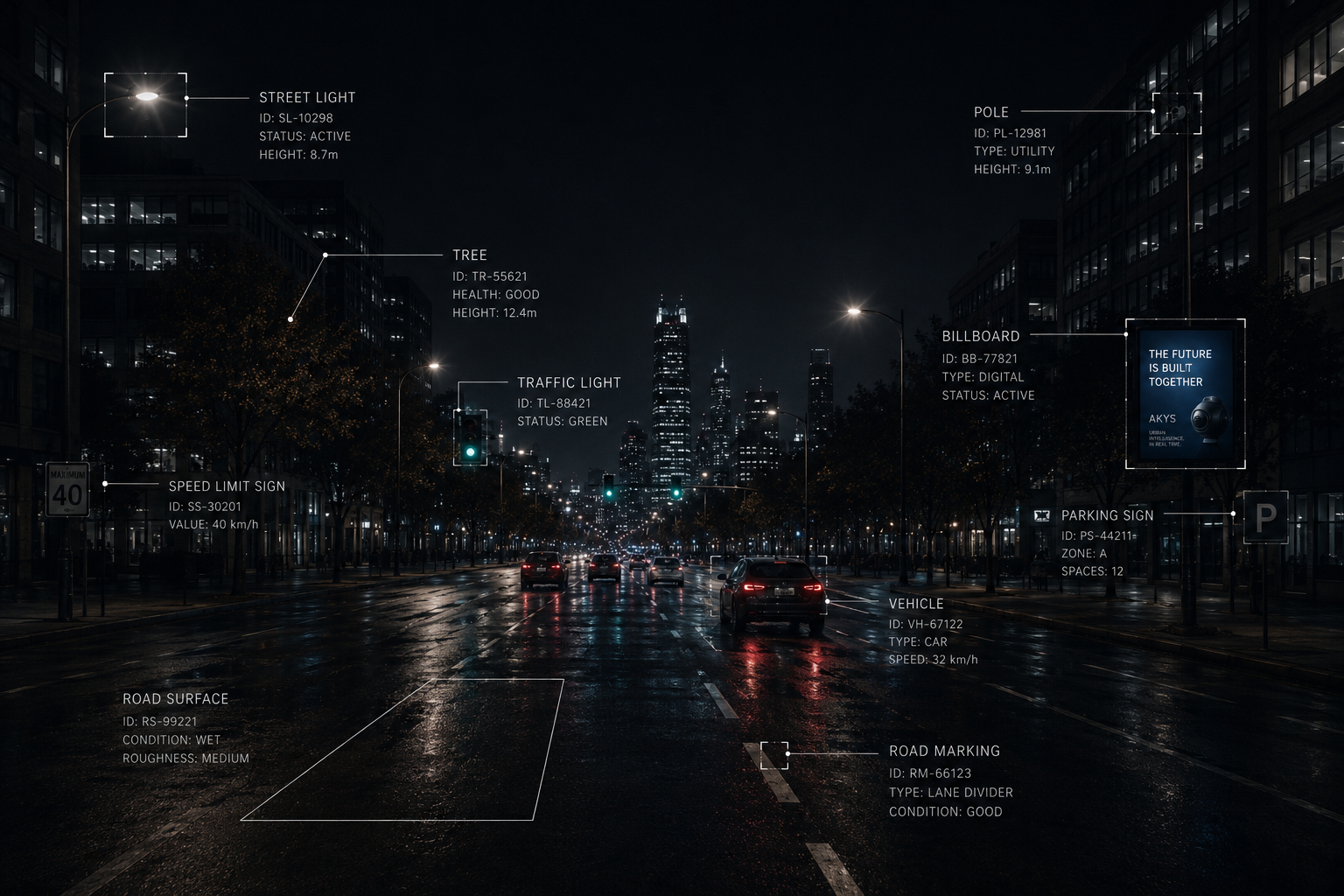
AKYS transforms 11K panoramas and LiDAR point clouds into structured urban intelligence using custom AI models trained for European road assets.

  • Spatial Motion Trackinganalyzes vehicle, pedestrian, and cyclist movement, traffic flow, and risk zones
  • GDPR Privacy Protectionautomatic real-time face and license plate blurring before data storage
  • AI 3D Depth Reconstructioncalculates real-world object distances and spatial positioning
  • Road Sign AI Inventorydetects and catalogs European road signs with GPS precision
  • Semantic Scene Segmentationidentifies roads, sidewalks, buildings, and vegetation for digital twins
  • Road Damage DetectionAI-driven detection of potholes, asphalt wear, and micro-cracks

Built for smart cities, mobility analytics, infrastructure inspection, digital twins, and autonomous systems.

Satellites and drones see roofs. We see streets.

We capture the city from the ground up, revealing what aerial imagery can't.

Learn More

A living digital twin of your city.

High-frequency scanning creates a dynamic digital twin you can explore, measure, and trust.

View Platform

Measuring today. Improving tomorrow.

We turn raw data into clean, trackable metrics to optimize maintenance schedules and improve urban mobility.

Start Measuring
Semantic Twin

Beyond 3D Maps.

AKYS Living Semantic Digital Twin
SYS: ACTIVE
LAT: 54.6872
LNG: 25.2797
ALT: 112.4m
PTS: 14,842k
ROAD [99.2%]
BUILDING [97.5%]
VEGETATION [94.1%]
SIGN: SPEED_50 [98%] H: 2.45m
POLE: UTILITY [96%] Tilt: 0.8°
CROSSWALK [94%] Wear: Faded (35%)
LIGHT: LED [91%] Lum: Active
VEHICLE: SUV [97%] Speed: 48 km/h

A standard map shows where a road is; a traditional 3D model shows what a building looks like. AKYS builds a semantic digital twin—a living virtual replica where every pixel and laser point knows its object, dimensions, and condition over time.

  • Terrestrial Advantage Capturing the city from the ground up. We map vertical architectural faces, areas beneath dense canopies, and exact roadside layouts that aerial mapping completely misses.
  • Time-Series Refresh Seasonal drives (spring and autumn) capture a chronological archive. Slide back in time to compare road degradation over winter or track canopy growth over summer.
  • Queryable Infrastructure AI-segmented layers turn the twin into an active, searchable database. Instantly query and filter for faded crosswalks, signs shorter than 2 meters, or PM10 dust zones.
Use cases

Built for the teams that keep cities moving.

AKYS gives operational teams a shared, ground-level layer of truth for planning, maintenance, safety, and infrastructure investment.

AKYS sukurta komandoms pritaikymas
Company

Driven by Speed. Built for Reality.

At AKYS, we are a lean team of spatial engineers and developers on a mission to make the physical world completely queryable. We believe that managing a modern city shouldn't require expensive enterprise software licenses, outdated data archives, or heavy desktop installations.

By combining high-tech mobile sensors with our own automated AI processing pipelines, we deliver fresh, high-frequency digital twins directly to your web browser. We skip the corporate bureaucracy to give Baltic municipalities and utility leaders the instant, real-world clarity they need to build safer, smarter communities. We don't just map—we build the intelligent foundation for tomorrow's infrastructure.

±3 cm

Precision Mapping

Centimeter-level accuracy using dual LiDAR, RTK GPS, and high-frequency IMU sensors.

100%

GDPR Compliance

Fully automated AI blurring of faces and license plates before processing or storage.

0 MB

Web Native

Explore, measure, and analyze high-resolution digital twins directly in your web browser.

Pilot scan

Ready to see your city differently?

Book a pilot scan and discover what your streets are already telling you.

AKYS bandomasis važiavimas su miesto infrastruktūros objektų atpažinimu